
The performance and efficiency of crop protection can be greatly improved. The updated route operation mode includes connecting routes, so that the aircraft can automatically fly to the mission route and avoid the obstacles that have been marked in the field planning. The new smart supply reminder calculates the amount of liquid remaining to help users manage spraying operations.
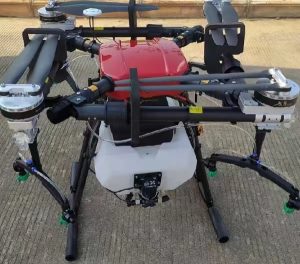
2: The aircraft is equipped with a spherical radar system, which is a pioneering new agricultural system. The system is composed of omnidirectional digital radar and uplink radar, and provides terrain tracking, obstacle sensing and obstacle avoidance functions. Through the front and rear FPV cameras and bright spotlights, the system fully ensures the safety of day and night operation under different weather conditions.
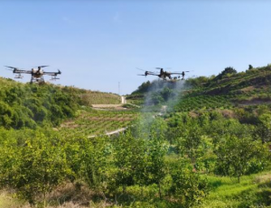
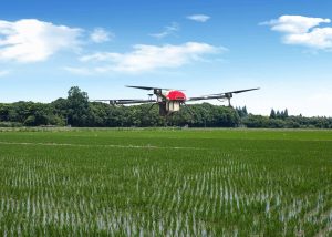
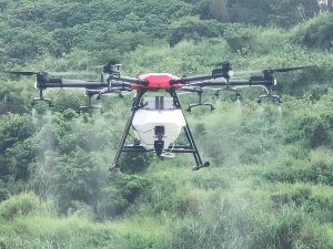
3: Thanks to the innovative new plunger pump and 16 sprinklers, the spray system provides improved spray width, rate, distribution and efficiency. Dual channel electromagnetic flowmeter and continuous level gauge make the measurement more accurate than ever before. To spray the orchard, the user can purchase the optional orchard spray package and convert the aircraft to the orchard configuration. During orchard spraying, with the help of the new spherical radar system and DJI Agras cloud, the branch aiming technology can be used for accurate spraying. The protection level of the aircraft is IP67 (IEC 60529), and the core components have three layers of protection, making T30 corrosion-resistant, dust-proof and waterproof, so it can be directly washed with water.
![图片[1]-16 Liters 16L Spray Spraying Drone For Agriculture Irrigation Purpose UAV Agricultural Drone Sprayer-msoen](https://www.msoen.com/wp-content/uploads/2022/08/a539ddec90dc.png)
4: Intelligent controller enterprises use DJI ocusync TM enterprise transmission technology, with a maximum transmission distance of 7 km [1], and support Wi Fi and Bluetooth. The remote controller has a 5.5-inch bright dedicated screen and built-in updated DJI Agras application, providing a smooth and easy-to-use experience. When the RTK dongle is connected to the remote controller, the operation can be accurate to the centimeter level. The multi aircraft control mode [2] of the remote controller can be used to coordinate the operation of multiple aircraft at the same time, so that the pilot can work efficiently. Both internal and external batteries can be used to power the remote controller. The working time of the remote controller is up to 4 hours, which is an ideal choice for long-time and high-intensity operation.
Features and highlights
1: T30 adopts a new quadrilateral folding structure design, which can be quickly folded and easy to store. The folding detection sensor built in the rack arm enables the aircraft to perform self inspection of the folding mechanism to ensure that the arm is properly deployed. When used with airborne d-rtk TM, the aircraft supports centimeter level positioning [3], and dual antenna technology provides strong anti-magnetic interference capability. Due to the dual FPV cameras, the user can clearly see the front and rear of the aircraft.
2: The updated routing operation mode includes connection routing. In the connecting route, the aircraft will automatically return to the task route. The user can mark obstacles outside the mission area to avoid during the on-site planning of the aircraft, and can also add connection points to make the aircraft return to the mission route along the connection route. The intelligent supply reminder can further automate the operation, calculate the remaining liquid volume in real time and display the filling point on the map.
3: Crosshairs can be used to add boundary points and obstacle points in site planning, making the user’s operation easier than ever before. The aircraft can perform variable rate fertilization by importing the prescription map into the remote controller and applying it to the farmland.
4: The spherical radar system is composed of omnidirectional digital radar and uplink radar. It provides altitude detection and stability in the forward, backward and downlink directions, and provides obstacle detection in all horizontal and uplink directions in the route, A-B route and manual + operation mode. The radar can detect the angle of the slope and automatically adjust it to maintain the distance from the ground, even in mountainous areas. Under the operation mode of route and A-B route, the radar can effectively sense obstacles and plan a route to actively bypass obstacles. Obstacle avoidance is disabled by default and must be enabled in the application.
Error reporting notes
Pinyin (Bilingual)

Please sign in to comment
register